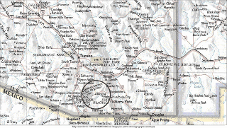
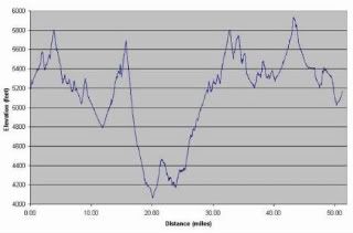
I'm officially registered to run another 50 miler, this will be number 3 scheduled to take place on March 7, 2009 here in Tucson. This is all I know about the race, the only other thing I need to know is location of aid stations to mind sculpt through the race.
 "Remember that happiness is a way of travel - not a destination".
- Roy M. Goodman


3 comments:
Hello - Just signed up for this run. Thanks for the elevation chart...could not find that. I to am looking for the aid station locations. I'll post if i find them...thanks again.
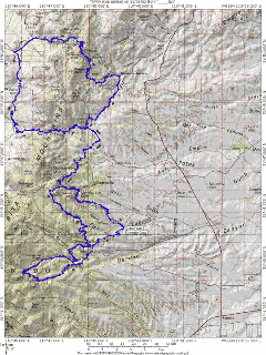
Name and location of aid stations:
Kentucky Camp (Start/Finish)
Located on FS163.
Latitude 31°44’43”N; Longitude -110°44’30”W NAD83 DATUM
Open 5:30am - Close 9pm
Aid Station 1 & 7 - Granite Mountain [3 & 33 Miles]
Just west of junction FS163 & FS165 on FS165 AZ trail crossing.
Latitude 31°45’45”N; Longitude -110°46’30”W NAD83 DATUM
Open 6am - Close 4:30pm
Aid Station 2 & 6 - California Gulch [7 & 29 Miles]
Just west of Greaterville Road on Box Canyon Road (FS62) at AZ trail
crossing.
Latitude 31°47’34”N; Longitude -110°44’50”W NAD83 DATUM
Open 6:30am - Close 3pm
Aid Station 3 - Wasp Canyon [13 Miles]
Junction FS231 and FS4051
Latitude 31°49’47”N; Longitude -110°45’00”W NAD83 DATUM
Open 7am - Close 10am
Aid Station 4 - Helvetia [19 Miles]
South Helvetia Road (FS505) just east of Helvetia cemetery
Latitude 31°51’14”N; Longitude -110°48’14”W NAD83 DATUM
Open 8am - Close Noon
Aid Station 5 - Box Canyon [25 Miles]
Box Canyon Road (FS62) at west forest service boundary and east boundary of
Santa Rita Experimental Range.
Latitude 31°47’57”N; Longitude -110°47’54”W NAD83 DATUM
Open 8:30 am - Close 1:30 pm
Aid Station 8 - Cave Canyon [40 Miles]
Junction FS92 and FS4084
Latitude 31°42’54”N; Longitude -110°45’52”W NAD83 DATUM
Open 10:30 am - Close 6 pm
Aid Station 9 - Gardner Canyon [46 Miles]
FS785 and AZ Trail crossing (1/4 east of FS92).
Latitude 31°42’47”N; Longitude -110°45’40”W NAD83 DATUM
Open 11:30 am - Close 7:30pm
Aid stations Map:
http://www.oldpueblo50.com/Map_files/landsat_
map_files/LandSat16M.jpg
Post a Comment